


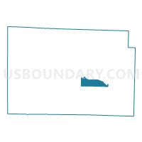
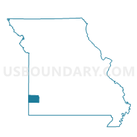
SOUTH MADISON Voting District, Jasper County, Missouri
About
Outline

Summary
| Unique Area Identifier | 608775 |
| Name | SOUTH MADISON Voting District |
| County | Jasper County |
| State | Missouri |
| Area (square miles) | 9.18 |
| Land Area (square miles) | 9.12 |
| Water Area (square miles) | 0.06 |
| % of Land Area | 99.34 |
| % of Water Area | 0.66 |
| Latitude of the Internal Point | 37.16717320 |
| Longtitude of the Internal Point | -94.23487740 |
Maps

Graphs
Select a template below for downloading or customizing gragh for SOUTH MADISON Voting District, Jasper County, Missouri


Neighbors
Neighoring Voting District (by Name) Neighboring Voting District on the Map
- CARTHAGE WARD 4-1 \ WARD 4-2, Jasper County, MO
- CARTHAGE WARDS 1-1 \ 1-2, Jasper County, MO
- CARTHAGE WARDS 2-1 \ 2-2, Jasper County, MO
- CENTENNIAL \ GEM Voting District, Jasper County, MO
- MCDONALD Voting District, Jasper County, MO
- NORTH MADISON Voting District, Jasper County, MO
- REEDS / LA RUSSELL Voting District, Jasper County, MO
Top 10 Neighboring County Subdivision (by Population) Neighboring County Subdivision on the Map
- Marion township, Jasper County, MO (15,137)
- Jackson township, Jasper County, MO (4,954)
- Sarcoxie township, Jasper County, MO (3,043)
- Madison township, Jasper County, MO (2,502)
- Union township, Jasper County, MO (2,296)
- McDonald township, Jasper County, MO (810)
Top 10 Neighboring Place (by Population) Neighboring Place on the Map
Top 10 Neighboring Elementary School District (by Population) Neighboring Elementary School District on the Map
Top 10 Neighboring Unified School District (by Population) Neighboring Unified School District on the Map
Top 10 Neighboring State Legislative District Lower Chamber (by Population) Neighboring State Legislative District Lower Chamber on the Map
Top 10 Neighboring State Legislative District Upper Chamber (by Population) Neighboring State Legislative District Upper Chamber on the Map
Top 10 Neighboring 111th Congressional District (by Population) Neighboring 111th Congressional District on the Map
Top 10 Neighboring Census Tract (by Population) Neighboring Census Tract on the Map
- Census Tract 117, Jasper County, MO (6,467)
- Census Tract 120, Jasper County, MO (5,417)
- Census Tract 116, Jasper County, MO (5,232)
- Census Tract 121, Jasper County, MO (3,791)